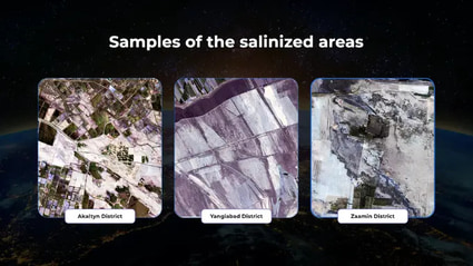
The Uzbekcosmos Agency has announced the launch of a pilot project to monitor soil salinity using satellite images. The initiative is being implemented jointly with the United Nations Economic and Social Commission for Asia and the Pacific (ESCAP). Uzbekcosmos announced this at a seminar for local and international experts.
According to the agency, 1.74 million hectares of land in Uzbekistan are getting salinized to varying degrees, of which 65.2 thousand hectares are classified as highly saline. An additional 5.5 million hectares have turned into salt marshes as a result of the drying up of the Aral Sea.
“Salinization reduces the availability of water for plants, worsens soil fertility, and leads to the loss of minerals and microelements. Therefore, the relevance of monitoring and finding solutions in this area remains high,” said Ismail Rasulov, head of the department of innovation and technology transfer in the space sector at Uzbekcosmos, in his speech.
The project will cover 90 crop areas in the Zarbdar district and adjacent territories in the Jizzakh region. For two years, specialists will study their salinity level. For its assessment, the vegetation indices (NDVI) and salinity indices (SSI) will be used, explained the head of the department of the Center for Space Monitoring and Geoinformation Technologies Farkhod Makhmudkhodjaev.
Both are calculated based on satellite images that record not only the visible spectrum (RGB, looks like a regular satellite image), but also infrared and other invisible ranges. NDVI will determine the condition and density of vegetation, and SSI will help assess the degree of salinity in the area.
Using only two indices to monitor soil salinity is not enough, noted Professor of the Chinese Academy of Agricultural Sciences Miao Lu. Additional vegetation indices will help improve the accuracy of the analysis. Among them are the soil-adjusted vegetation index (SAVI), the ratio vegetation index (RVI), and specialized indices for salinity monitoring: the normalized difference salinity index (NDSI) and the soda soil salinity indices (SSSI).
Uzbekcosmos intends to take the professor's recommendations into account, but during the pilot project, the purpose of which is to demonstrate the possibility of conducting such monitoring, additional indices will not be used.
The project will reduce the need for large-scale field sampling, speed up the data collection process, reduce the cost of laboratory research and automate the assessment of salinity, said Farkhod Makhmudkhodjaev. Monitoring soil salinity in large areas will become more effective. In addition, it will become easier to identify them, and the volume of field research will decrease.
Thanks to satellite images and the indices used, specialists will be able to immediately identify areas with an increased likelihood of salinization, which will reduce the cost of the survey. Soil samples will be collected pointwise - only in potentially problematic areas. The parameters will then be specified in the laboratory.
The agency is in preliminary talks with the Research Institute of Soil Science and Agrochemistry, which will provide laboratory facilities for the study.
“This approach will facilitate the development of land management strategies,” concluded Farkhod Makhmudkhodjaev.
ESCAP Economic Affairs Specialist Kareff Rafisura noted that the global goal of the initiative is to improve data collection and analysis. This will help assess Uzbekistan’s progress in achieving the Sustainable Development Goals (SDGs). Based on the research results, ESCAP will adapt international standards for addressing environmental and agricultural issues to the conditions of Uzbekistan.
Kareff Rafisura added that the project will also strengthen the capacity of government agencies. This will be achieved through the use of artificial intelligence and the creation of an open data platform. The latter is especially important for strategic planning for soil restoration and land management.
Space monitoring data will be transferred to government agencies, including the ministries of ecology, agriculture and water resources, said Ismail Rasulov, head of the department of innovation and technology transfer in the space sector. In addition, it is planned to create an open geo-platform, where any user will be able to obtain analytics on land resources. The project will be the first in Uzbekcosmos to offer open access to such data.
"Separate portals have already been created for many space monitoring projects, but the information contained in them has limited access, since it includes government data and registries. We transfer them only to government agencies. However, in this project, implemented with the support of an international organization, openness of data is one of the key requirements of our partners," Ismail Rasulov explained.